1.Hydrotechnical department
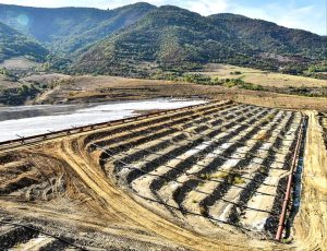
Pursuant to executed contracts, the department has developed major projects for mining and processing enterprises across the Republic of Armenia. These projects include the design of tailings storage facilities, dams, tailings pipelines (including syphons, tunnels, and other hydraulic structures), canals, and reservoirs. Notably, the department has prepared tailings storage facility designs for the following mining operations: Teghout, Vallex Group, Akhtala, Kajaran, Agarak, Ararat, and Kapan.
The work is carried out using modern licensed software, including AutoCAD, Microsoft Office, Adobe Acrobat, and Pipe Flow.
The Hydrotechnical Department is staffed with highly qualified specialists who are fully equipped to develop projects in compliance with international standards for all types of hydraulic structures. These include hydroelectric power plants, reservoirs, drainage canals, pressure and non-pressure pipelines, water supply systems, water infrastructure for mining enterprises, and pumping stations.
Licensed international software
| № |
Name |
| 1 |
AutoCAD |
| 2 |
Microsoft Office |
| 3 |
Adobe Acrobat |
| 4 |
Pipe Flow Expert |
| 5 |
Pipe Flow Wizard |
| 6 |
Pipe Flow Advisor |
2.Water supply department
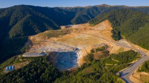
The Water Supply Department develops all the necessary projects for mining and processing enterprises in Armenia. Specifically, for Teghout, Vallex Group, Kajaran, Agarak, and Ararat. These projects include reservoirs, pumping stations, water pipelines, treatment facilities, on-site and off-site water supply and sewage networks, drainage water diversion from tailings storage facilities, and internal water supply and drainage systems for industrial enterprises.
The work was carried out using licensed software, including AutoCAD, Microsoft Office, Adobe Acrobat, and Pipe Flow.
The Water Supply Department is ready to develop projects that meet international standards for mining and processing enterprises in the areas of water supply and sewage systems.
Licensed international software
| № |
Name |
| 1 |
AutoCAD |
| 2 |
Microsoft Office |
| 3 |
Adobe Acrobat |
| 4 |
Pipe Flow Expert |
| 5 |
Pipe Flow Wizard |
| 6 |
Pipe Flow Advisor |
3.Geotechnical department
The Geotechnical Department conducts geotechnical investigations of the foundations and dams of tailings and water reservoirs, assesses the technical condition of tunnels and retaining walls, and evaluates the stability of foundations of hydraulic structures. In addition, the department studies the physical and mechanical properties of soils and materials, and analysis hydrogeological and geophysical data, providing accurate and reliable data essential for project implementation. The department performs field and laboratory soil investigations (drilling, sampling, testing), analysis the physical, mechanical, and hydrological characteristics of soils, designs foundations for buildings, bridges, dams, tunnels, and other structures, calculates the stability of slopes, embankments, and fills, and develops solutions for soil stabilization or deformation prevention (e.g., landslides).
Licensed international geotechnical software
| № |
Name and Model |
| 1 |
Geo5 Software version 5.2024.116.0 |
| 2 |
GeoStudio Software 2019 R2 |
| 3 |
CPeT-IT Software v.3.9.3.7 |
| 4 |
CLiq Software 3.0 |
Available equipment
| № |
Equipment |
Model |
Function |
| 1 |
CPT |
TG 63-150 |
Crawler-mounted drilling rig |
| 2 |
Packer testing/Lugeon Test |
Single packer |
Hydrogeological geotechnical testing |
4.Engineering-geological survey department
Engineering-geological surveys are conducted through visual inspection, borehole drilling, and excavation of underground workings. These investigations determine the stratification of soils at the project sites, the depth of soil contacts, hydrogeological conditions, and the physical and mechanical properties of the soils. Soil condition indicators are also identified. The work is carried out in accordance with national and international technical standards and procedures, in line with the applicable norms and regulatory documents.
Available equipment
| № |
Equipment |
Model |
| 1 |
Drilling rig |
URB 2A-2 rotary drilling rig |
| 2 |
Drilling rig |
UGB-1VS Universal Geological Drilling Rig |
| 3 |
Drilling rig |
UGB-1VS Universal Geological Drilling Rig |
| URB 2A-2 Rotary Drilling Rig |
| Maximum drilling depth with flushing |
|
|
|
m |
350 |
| Drilling depth with air flushing (one/two compressors) |
m |
30/50 |
| Initial drilling diameter with air flushing |
mm |
300 |
| Final drilling diameter with air flushing |
mm |
110 |
| Initial drilling diameter with flushing |
mm |
450 |
| Final drilling diameter with flushing
-in hard rocks
-in soft rocks |
mm |
190
294 |
| Drill bit rotation speed |
|
|
| Speed 1 |
rpm |
140 |
| Speed 2 |
rpm |
225 |
| Speed 3 |
rpm |
325 |
|
| UGB-1VS Universal Geological Drilling Rig |
| Nominal drilling depth (auger Ø135-180 mm) |
50-12 m |
| Drilling of vertical wells (Ø130-300 mm), with a drilling depth up to |
45 m |
| Transport base of the drilling rig |
ZIL 131 |
| Mast height |
8,65 m |
| Rotary drive stroke |
3,2 m |
| Mast lifting capacity |
52 kH |
| Rated power of the main drive |
44 kW |
| Maximum torque |
5000 nM |